Wednesday, July 23 2014
Wouldn't it be nice if we all had access to geologists, drilling crews, and huge rock crushers to sample hardrock deposits? Well, if that's not in your budget but you still need to determine if an outcropping or vein might be promising before you stake a claim, a portable Cobra Crusher and a few grab samples can work nicely. A grab sample is just that -- randomly chosen rock samples you need to crush and test for gold or other precious metals. Although grab samples can seem counter productive because of the randomness, they can still provide you with a basic, overall understanding of the area and the possibility of higher grade ores in the vicinity. When looking for a grab sample, choose mineralized portions of the vein, pieces of mine dumps near a portal or shaft, or chunks of mineralized float that have broken away from the vein. Mineralized quartz on a mine dump near a mine portal or shaft makes for good grab samples. Often the operators of small mines had to sort and ship only the best of the ore. That means high grade materials can be left behind in mine dumps. What's especially great about the Cobra Crusher is that it's portable and light weight. You don't have to collect and then lug around heavy rocks and wait until you get back home or to your camp to know if they are worth anything. You can crush a few small rocks right in the field, then pan out the powder to see if its gold bearing. Having a small light-weight crusher with you in the field saves guess work. You'll know for sure right there and then if the site you've discovered is worth further consideration. If you don't have water to pan the powder on the spot, crush the rock and store the powder in a plastic bag. Label the bag with GPS coordinates so you know EXACTLY where you got it. Then, after you've panned it later, if you find it contains a good bit of gold, you will know exactly where to return for further testing. It's also helpful to snap a photo of the place where you collected the rock. Matching the GPS coordinates with your photo ensures you'll be able to get back to that exact spot at a later date. In addition to collecting rocks, you might want to take some chip samples from a wide vein. Use a rock hammer to break off small pieces and then run them through the Cobra Crusher. Again, pour the powder into a well labeled bag if you can't pan in the field and can wait until a later time to get the results. When preparing for a sampling expedition, use the information on your local Bureau of Land Management website or in their office. In these files, geologists might have made notes about the specific mines in the area, and/or there will be details about the ore grade, tonnage and past production -- all good indicators so you don't waste your time. Mine maps can often be found in these files as well. You might be able to locate old stopes or mapped veins. This information can tell you where high grade ores were found in the past, which is where you might want to explore today. Thursday, July 03 2014
Victor, Colorado -- the City of Mines Victor is a small quaint mountain town now, but back in the late 1890s, more than 8,000 lived and worked here. By the time the town was platted in 1893, it was already known as the City of Mines because the largest and richest gold mines of the Cripple Creek and Victor District were located on Battle Mountain just above town. Today, several headframes still jut into the sky, and brick buildings dating to 1899 still line the streets. Between 1899 and 1902, booming Victor boasted 48 saloons, 29 doctors, 15 restaurants, 12 banks, eight pharmacies, six churches, five architects, two newspapers and more. In early 1899, a fire destroyed the original false-front pine buildings and left 3,000 people homeless. Within six months, though, the businesses were rebuilt in brick or stone. Just like in Cripple Creek, Victor saw its share of the Colorado Labor Wars, too. The Western Federation of Miners union hall on 4th Street has some telltale bullet holes to prove it! Interpretive signs posted at intersections around Victor relate colorful stories about the Red Light Social Clubs, the famous girls who entertained at the Fortune Club, and about the town’s founders. Take a walk and envision the streets as they would have been over 100 years ago. If you need a little help imagining yesteryear, the photographs in the Lowell Thomas Museum depict life in early Victor, and it is also the best place to learn about the town’s pioneers. The museum’s namesake is none other than the internationally renowned radio news broadcaster, author, and film producer Lowell Thomas. Between 1930 and 1976, Mr. Thomas’s 15-minute nightly news and commentary aired just before the famous Amos ‘n Andy Show, and had a audience numbering more than that of the NBC, CBS and ABC TV news anchors combined. Victor was Lowell Thomas’s boyhood home. American Eagles Scenic Overlook
In 1895, the American Eagles Mine at this site was the highest underground mine in the district. This mine had three shafts, the deepest had reached 1,540 feet by 1902. Shafts are vertical excavations through which miners and supplies are taken into and out of underground workings. Headframes sit above the vertical shaft in order to support the sheave wheel or pulley system that passed the hoist cable from the steam or electric-powered hoisting mechanism to the metal cage that hauled men and supplies. Tunnels on the other hand, are horizontal excavations, driven from the surface into the side of a hill to connect with the underground workings some distance away. Technically speaking, tunnels have surface openings on both ends. A one-opening tunnel is an adit.
On your drive up to the American Eagles Scenic Overlook, expect to stop at a checkpoint and give your name to a Cripple Creek and Victor Gold Mining Company employee. Your visit is welcomed, so the checkpoint is for nothing other than your safety. You’ll be told if it is OK to proceed (the road is closed during blasting), and will be cautioned about the giant haul trucks that share part of the same road. Access the American Eagles Scenic Overlook north of Victor at the intersection of County Roads 81 and 83 on Bull Hill Pass. The route is signed. Trails of GoldThe remains of many mining operations pepper the landscape in and around Victor. Quite a few sites are connected by hiking trails (pick up a map at the visitor center in Victor). These “Trails of Gold” offer up-close looks at more relics of yesteryear as well as active mining activities. The trails include good signage about the area history. Some buildings are heaps of rubble, some are still standing— it all depends on Mother Nature. Be careful when exploring these sites, and if you’re normally a flatlander, remember that you’re trekking at elevations of 9,500-10,500 feet above sea level.
Cripple Creek and Victor continue to pay tribute to their 1890s heritage as The World’s Greatest Gold Camp. In and around these tiny towns, much of the area’s gold rush history has been preserved and continues to be a source of pride for the Centennial State (the nickname comes from Colorado becoming the 38th state, 100 years after the signing of the Declaration of Independence). Whether you want to tour gold mines, participate in year-round special events, visit museums, or just marvel at the historic headframes and other vestiges of mining equipment backdropped by mountain views, there’s a wealth of activities and sites to keep you interested and entertained. This photofeature by Denise Seith also appears in the May/June 2014 issue of Gold Prospector Magazine, published by the Gold Prospectors Association of America. Wednesday, July 02 2014
The Town of Cripple Creek, Colorado
In addition to its golden history, the restored town of Cripple Creek is now known for its casinos. Limited stakes gambling was approved by Colorado voters in 1990, so visitors can try to strike it rich 24 hours a day. If cards or craps or one-armed bandits don’t hold any appeal, skip the dozen or so casinos in town and instead enjoy the town’s many other attractions.
The Cripple Creek District Museum is housed in five original historic buildings— all filled with antiques and mining equipment. The Cripple Creek Heritage Center is a great place to learn about the entire Pikes Peak region. Looking for a highlight found in low lighting conditions? The Mollie Kathleen Gold Mine is located just outside of town, and is America’s only vertical shaft mine tour. After descending 100 stories, ride an air-powered mine train and learn how hard rock miners followed veins of gold. This historic mine was founded in 1891 and is named for its owner, Mollie Kathleen Gortner, the first woman in history to register a mining claim in her own name. Cripple Creek and Victor Gold Mining Company (CC&V) As you drive through the mining district today, you will see signs of active mining in just about every phase. The Cripple Creek and Victor Gold Mining Company (CC&V) operates a low-grade, surface gold mine, the largest in Colorado, between Cripple Creek and Victor. CC&V is doing extremely well and has poured in excess of 4 million ounces of gold from its Cresson Mine. CC&V, which has operated in the district for nearly 40 years, began its Cresson Project in 1995. The Cresson is named for the historic underground mining operation that was responsible for the famous great gold find of 1914— the “Cresson Vug.” A vug is a cavity in the rock, lined with crystals somewhat like a geode. The Cresson Vug produced 60,000 troy ounces of gold that was essentially picked from the walls of a room-sized void 1,200 feet below the surface. What a bonanza! If you’d like to see a working gold mining operation, CC&V hosts seasonal tours. Don’t miss this exciting opportunity to see giant haul trucks, shovels, and drill rigs in action. Watch boulders being crushed into gravel and learn about the safe, environmentally responsible mining and refining methods. Once you’ve seen a modern-day mining operation for yourself, you’ll gain another level of appreciation for the old-timers who didn’t have it so easy! And after learning about reclamation standards, you can set the record straight with those who argue that mining does nothing but permanently destroy the earth. Under current permits, CC&V plans to continue recovering gold here until at least 2026. If underground mining is resumed (exploratory results look good), work could be extended another dozen or so years beyond that. With an average pay and benefits package worth $80,000, several thousand CC&V employees are enjoying good paying jobs!
Tuesday, July 01 2014
Like most gold regions that boomed in the 1800s, Colorado’s Cripple Creek Mining District came from humble beginnings. Little more than cattle roamed the high valleys perched nearly two miles above sea level, and prior to ranching, generations of Ute Indians had lived off the land. But unlike most boomtowns, the gold never completely ran out here, and it continues to be mined successfully today. Historically, the Cripple Creek Mining District has produced over 24 million troy ounces of gold, along with some silver. That amount exceeds the combined production of the California and Alaska Gold Rushes! The millions made from 1891 through the present has earned it the distinction of “The World’s Greatest Gold Camp.” Today, the district is not only filled with gold rush era buildings and mining relics, but you can also tour real mines, visit interesting museums, ride the rails of a narrow gauge train, hike and bike while admiring mountain scenery, and even gamble on Lady Luck at the casinos. Pikes Peak Gold RushThe Pikes Peak Gold Rush officially began in 1859, a decade after the California Gold Rush. At that time, the land was still part of the Kansas Territory. The first color was actually found a few years earlier in 1850 at the confluence of Ralston and Clear Creeks, but John Ralston was California-bound, so the shiny stuff stayed where it lay… for a while. Several prospecting parties returned to Ralston Creek in 1858 and 1859, but didn’t find much. In fact, many were so discouraged that they didn’t stick around. The dedicated prospectors who persevered referred to those who gave up as the “Go Backers.” Soon enough, though, a few productive placer deposits were found along the South Platte River at the base of the mountains, the canyon of Clear Creek in the mountains west of Golden, and South Park. Word spread of these glittering discoveries, and “Pikes Peak or Bust” became a popular mantra. During the next several years, 100,000 gold-seekers headed for Colorado; 50,000 completed the journey; half of those became “Go Backers” and the remaining 25,000 turned a territory into a state in 1876. Cripple Creek Gold RushMost of the initial easy-to-reach gold deposits were largely played out by 1863, but then ranch hand Robert Womack started an even bigger gold rush. He found the shiny stuff in Cripple Creek in 1890, causing thousands of prospectors to head to the southwest slopes of Pikes Peak. Sadly, Womack died penniless several years later, even though his El Paso claim, which he sold for $500 and a bottle of liquor, produced millions of dollars in gold for the buyer. Between 1894 and 1917, over 500 mines operated in the Cripple Creek Mining District, which also included the thriving town of Victor. Headframes and other relics from many of those historic mines have been preserved, so it’s easy to get a good look up close. Perhaps one of the reasons it took 30 years for gold to be found in Cripple Creek following the state’s first gold rush is because no one expected gold, especially not millions of ounces, to be in this area. Most of the old-timers’ theories about how to locate gold just didn’t hold up here. Modern geologists know that areas that were highly volcanic in prehistoric times, are likely places to create rich underground deposits. The six square miles that comprise the Cripple Creek & Victor Mining District are located in the caldera of an extinct volcano. From what one frustrated miner wrote in Cripple Creek Illustrated, some early prospectors were stumped by the gold in this region: “Geographically, Cripple Creek is a freak. It is erratic, eccentric, and full of whims and caprices. That is, it is so to the man of science and the miner of experience. It is a vast crater bed in which the elements once were wont to make merry with nature and play unexpected pranks… The veins run here, there, and everywhere, cutting in all directions and even violating the theory that to have real value the vein should strike toward the poles of the earth.,, the experience has been that the deeper down into the earth the shafts penetrate, the richer is the ore, and the wider, more solid, and enduring the deposits.” Sunday, June 01 2014
At the consolidated court hearings held in San Bernardino County in California on May 1, Judge Gilbert Ochoa heard arguments from attorneys David Young and James Buchal on behalf of the miners. He had already received all the supporting documents and arguments from each of the involved parties. One of the key questions Judge Ochoa asked of attorneys representing the State of California was if they could provide a date when the current moratorium will end. The answer was, "No, Your Honor." Saturday, May 03 2014
The abbreviation kHz stands for ”kilohertz” which is the measurement of radio frequency radiation. A Hertz is the unit of measurement for counts per unit of time. Frequency is the number of occurrences of a repeating event per unit time. The higher the frequency, the more waves travel through space during a given time
PI (pulse induction) detectors work a bit differently by putting magnetic field energy into the ground and then switching off and waiting a short period before they start to look for a response. This makes them better at handling ground mineralization than a VLF machine because during that short delay the magnetic response of iron trash minerals that you don't want to find dies out, but the signal from tiny bits of buried gold does, too. VLF detectors are more sensitive to finding the smallest bits of gold, but do not as easily cancel out ground mineralization. If you've been shopping for a metal detector, you might have noticed that the manufacturers list the kHz of each machine. But how do you know if a higher or lower frequency is better? In most situations, a few kHz one way or the other will have a negligible impact on performance out in the field. The importance of frequency is most noticed when you are hunting for one particular type of treasure over another. For example, if you are coin shooting at the park, you can opt for a lower frequency metal detector which will cost less. However, if your main objective is to find gold nuggets with your detector, consider a higher frequency machine such as the Fisher Gold Bug 2 or Garrett AT Gold. Tuesday, April 01 2014
Typical winter storms that regularly occur in gold country usually do not create enough havoc to force substantial amounts of "new" gold into movement. However, when major flooding like what happened in Colorado in September of 2013 is followed by a “bad” winter, a great deal of gold can be set free. When tons of rock, cobble, and boulders are swept downstream along bedrock during a huge storm, quite a bit of destruction occurs. Plants, weeds, and trees that normally grow along the river and gravel bars are washed away. And when a major storm or flood tears up large portions of a streambed, a fair amount of this newly-released gold, because of its weight, will be deposited along the riverbed and settle into cracks and crevices. Saturday, March 01 2014
Natural Factors to Consider Before Digging for Gold:
Saturday, February 15 2014
Among the many improvements made to mining technology during the Industrial Revolution, perhaps the most important involved drilling and blasting. In the early days, black powder, a relatively low-power explosive was the only blasting agent available. To use it, holes had to be pounded into rock by hand. Working in teams of two, one miner would hold a pointed steel chisel while the other hit it with a sledge hammer. Each hole had to be hand drilled to six or eight inches in depth. Needless to say, this was slow, tedious, and tiring work. During a 10-hour shift, a team could typically drill, load, and fire black powder charges in only eight or 10 holes. Depending on the size of the mine tunnel, that single blast could bring down three quarters to two and a half tons of rock. Dynamite, an explosive five times more powerful than black powder, was invented in 1866 by Swedish chemist, Alfred Bernhard Nobel (the Nobel Prizes awarded today were named after him). Nobel held 350 different patents; dynamite is his most famous claim to fame. By the mid 1870s, dynamite had largely replaced black powder in the mines.
Unfortunately, thousands of hard rock miners died before J. George Leyner of Denver, Colorado invented a better machine drill that all but eliminated deadly silicosis. The improved drill forced water into the drill hole and created a harmless mud out of the drill shavings. The mud acted as a very efficient wet grinding compound while also cooling the drill bit, and the flow of water flushed out the drill hole. Leyner patented his mechanism in 1897. This type of drill hasn’t changed much over the years, and is still used in modern-day hard rock mines. Sunday, February 02 2014
According to a recent article posted on foxnews.com, a mining supply company located in Auburn, California reported that business has been up by 10 percent. The boon in business is because in Placer County, rivers have dropped to historically low levels, opening new possibilities for prospectors. "Stuff that's normally submerged in water is now available," said James Hutchings, Sacramento chapter president of the Gold Prospectors Association of America. "The exposed cracks and crevices can hold chunks of gold that have washed down from the mountains." If you are heading to Auburn hoping to spot something shiny, also take some time to enjoy Old Town and learn the area's rich gold mining history. California State Highway 49, also known as the Gold Rush Highway, winds its way through a nine-county area that in the mid 1800s was home to more than 2,500 gold mining camps. Most of those camps disappeared after the gold ran out, but a few communities survived and even thrived. Auburn is one such city. There are over 60 restaurants, taverns, antique shops, art galleries, and unique specialty stores in Old Town. Check out the irregular shaped post office on Lincoln Way. It dates to1857 and was built directly over a branch of the Auburn Ravine (a stream still flows directly below). This post office is the oldest one in California housed in its original building, and is also the oldest continually operated post office west of the Mississippi. If Old Town seems vaguely familiar to you, it’s because it was featured in the 1996 film Phenomenon starring John Travolta, Kyra Sedgwick, Forest Whitaker and Robert Duvall. The crew filmed for a month in the fall of 1995 on Sacramento Street, as well as at places such as a bar, apple orchard, county courthouse, a park, and a lawyer's office. Roughly 125 million ounces of gold were taken from the hills in California’s famed “Gold Country” during the Gold Rush. Auburn was lucky in that it survived the boom and bust cycles typical of early towns. Conveniently located at the junction of Interstate 80 and Highway 49, it’s easy to stop in and experience a bit of its golden history.
Before becoming one of Auburn’s most famous attractions (corner of Lincoln Way and Commercial Street), this 1891 red and white firehouse was home to the Auburn Volunteer Fire Dept., one of the oldest volunteer groups west of the Mississippi. Organized in 1852, this group is still fighting Auburn fires. The Placer County Courthouse at 101 Maple Street was completed in 1898 and is listed on the National Register of Historic Places. It also houses a FREE museum that presents an overview of Placer County history and a nice collection of Native American artifacts. One of the best exhibits is 194 ounces of raw gold mined from Placer County soil. Known as the Joss House, this structure at 200 Sacramento Street in Auburn, California was built after the fire of 1855. It served as a temple and house of worship for the area’s Chinese population. In the 1880s, this block of Sacramento Street was known as “Chinatown Hill.” The Chinese concentrated here and operated laundry shops, opium dens and card rooms. Brewery Lane, just north of the Joss House, was the entrance to Auburn’s “red light district.” During the district’s illustrious history, a pious man seeking to burn out the ladies also unfortunately burned out some of the Chinese settlement. |
|
Nugget of News Blog |



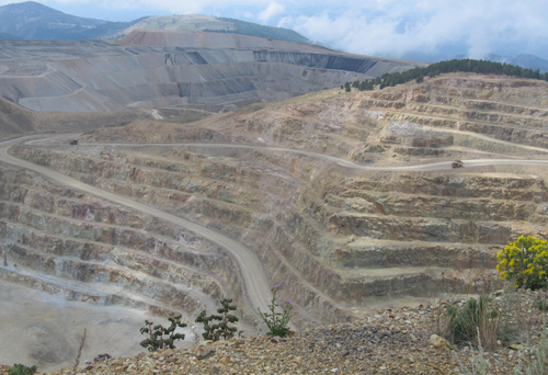 A few miles outside of Victor, you’ll find an impressive view of the Cripple Creek and Victor Mining District from atop the American Eagles Scenic Overlook. Stop at the Victor visitor center first (formerly a train depot) for a map. From an elevation of 10,570 feet, you get a bird’s eye look down into the CC&V surface operations where massive 240-ton haul trucks riding on 12-foot diameter tires haul ore up and down a abyrinth of roads. Mount Pisgah and the Sangre de Cristo and Collegiate Mountains make a nice backdrop.
 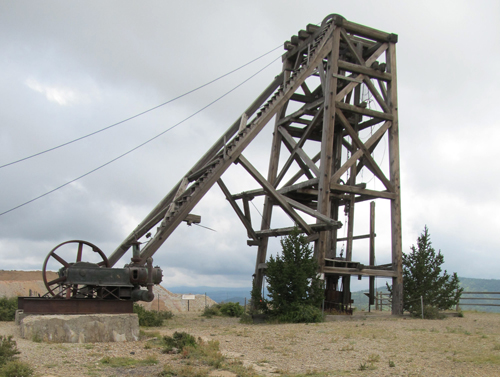 The original American Eagles headframe is still standing proudly, and the double-drum hoist is still in its place, too. The shaft, however, has been sealed. Remnants of a blacksmith shop and mine superintendent’s house are also at the overlook. Interpretive signs around the site tell the story of Winfield Stratton who purchased the American Eagles in 1895 after a huge success with his local Independence Mine. In fact, Mr. Stratton was Victor’s first millionaire and sold the Independence Mine for $11 million. The American Eagles was worked until 1940, but unfortunately little is known about its actual production since it was a private claim.
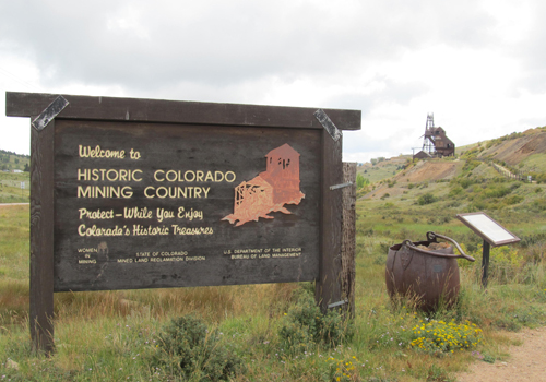 The Independence Town Site is an interesting stop. The steel headframe of the Vindicator Mine is hard to miss, and a gravel path takes you past what’s left of a surface plant, ore processing facility, and a residence that has definitely seen better days. Independence originated as Hull’s Camp on the Hull City placer claim. Although some placer gold was found, the real riches came from underground veins, so there were several different mines here. The Vindicator is credited with producing a total of 1,244,000 troy ounces of gold between 1895 and 1953. Also nearby is what remains of the Theresa Mine, which produced over 120,000 troy ounces between 1895 and 1961.
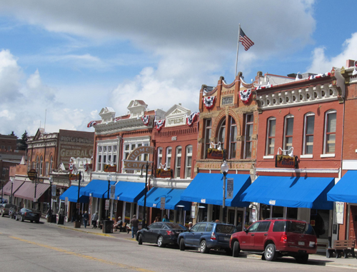
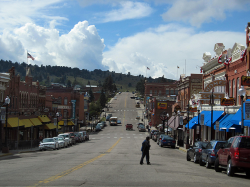 The gold rush not only brought prospectors into the quiet ranch town of Cripple Creek, but it brought in goods and services needed by those miners. Lumber yards, hotels, 100 saloons, 91 lawyers, 80 doctors, 40 assay offices, 14 newspapers, three railroads, two electric streetcar systems, and a trolley turned a small town into a booming gold camp of over 50,000. Interestingly enough, Cripple Creek was also the site of some of the worst mining labor conflicts in American history, culminating in the state militia being called in in 1903. Several celebrities also spent time here, including comedian and film star Groucho Marx, lawman and gambler Wyatt Earp, and boxer Jack Dempsey. Unfortunately, two accidental fires burned much of the city in 1896. Wisely, however, the city fathers declared that the business district be rebuilt in brick, and so many of those rebuilt buildings are still standing.
 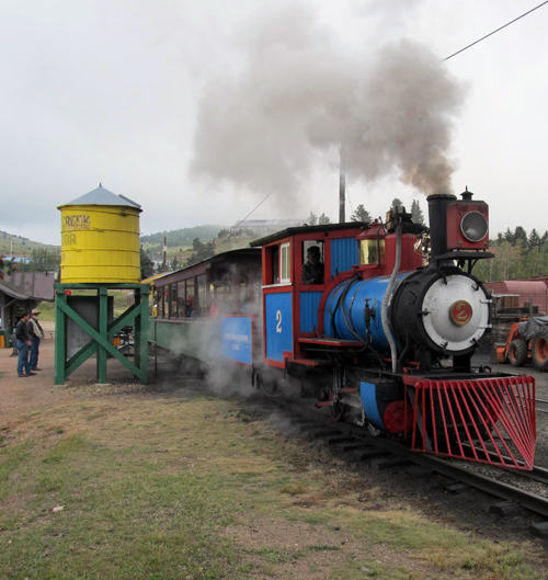 A four-mile narrated ride on the Cripple Creek & Victor Narrow Gauge Railroad passes several historical sites that can only be seen from the rails. The train is pulled by a coal-fired steam locomotive that looks a bit like Thomas the Tank Engine thanks to the baby blue paint. You can also see what it would have been like to be part of the criminal element in the early 1900s by visiting the Cripple Creek Jail Museum. It is housed in the red brick building that served as the Teller County jail from 1902 until the 1990s. The original cells are there, along with displays that highlight the laws and lawlessness of the 1890s.
 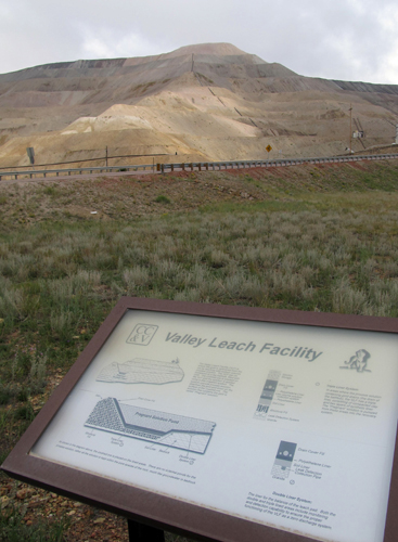 On Highway 67 between the towns of Cripple Creek and Victor, you will cross the highest bridge on the Colorado State Highway system. The bridge across Arequa Gulch was built in 2000-2001 for $418 million by the CC&V to accommodate their expansion. The 1,218 foot long bridge is over 250 feet tall at its highest point. The road is currently being rerouted again due to more growth. Near the bridge is CC&V’s leach facility and gold ore processing plant. The Valley Leach Facility (VLF) is where the gold is recovered from the ore by leaching with a sodium cyanide process solution. You can’t miss what looks like giant rock piles. The VLF actually functions like a big bathtub filled with crushed ore. The solution is applied to the ore using a drip irrigation system. The sodium cyanide process solution dissolves the gold and silver on the surface of the rock. The “bathtub” has a triple thick liner and a state-of-the-art monitoring and detection system to ensure zero discharge. The gold-bearing solution (called "pregnant solution”) is captured at the bottom of the liners. Gold is then recovered from the pregnant solution with a carbon absorption process. North of the VLF is the crushing facility that can process approximately 50 tons of ore per minute. Trucks load up the pulverized ore and delivery it to the VLF. This process recovers a whopping 200,000 ounces of gold annually. Eureka!
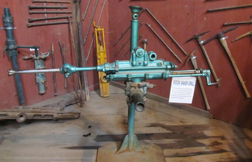 Around the same time period, pneumatic machine drills were first developed. Compressed air to power the drills was piped underground from large steam-powered compressors located at the surface. Machine drills could accommodate five to six foot drill steels that were capable of drilling three to four foot holes into sold rock in a matter of minutes. This new drill increased the tonnage of rock that could be blasted by two-man teams of miners to between four and 10 tons per shift. But, the new technology was not without hazards— namely the disease of silicosis. Machine drilling created clouds of razor sharp microscopic silica dust that miners breathed into their lungs. It took only a few years of operating this drill for a miner to develop this incurable disease.