Tuesday, November 01 2016
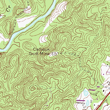
Researching and exploring new areas in which to prospect for gold, gems, or whatever you are seeking can be a lot of work, but the process can go much quicker and easier when you know where to start. If the weather where you live is keeping you indoors much of the time this winter, use your downtime wisely by researching and planning for next spring and summer. But don’t rely on just one source of information. Confirm it through several sources. It’s not that you don’t trust Uncle Joe or a “friend of a friend” tip, but facts can be distorted or forgotten over time and that “secret” nugget patch found 30 years ago just might not t The best kind of research brings together different forms of info from a multitude of sources. It is the info gleaned from COMBINED sources that can help you to determine the best possible place to locate precious metal or gems. The more info you can lay your hands on, the better. Consider these resources: Old mining district reports and mining history books. Most western states have some form of mining and geology agency, although they all have different names depending on the state. Find out what information is publicly available at the agencies located in the area you will want to prospect. Old history books can be more help than any state agency because they were written by folks with ties to the area they wrote about. That means they often include valuable information on old mining discoveries or operations that didn’t make it into a government report. Topographic maps. Many old mining areas are shown on topo maps, but usually not on the newer versions, so try and find older topo maps. Many of the newer versions may have old mines removed as a way for the government to “keep the general public safe” by not advertising the whereabouts of the old and “dangerous” mine shafts. Aerial photos. Google Earth is amazing in its quality and detail of photos. Many times you can see individual trees, hiking trails, rock outcrops and even hand-stacked piles of rocks left behind by old-timers. Sometimes larger features and patterns (areas where miners removed a lot of brush, for example) cannot be seen from ground level, but are obvious from far up in the sky. This is also a good way to get an idea of the condition of the roads in the area so you’ll know in advance which look to be commonly traveled. Google Earth ties in with GPS, too. You can review the photos, check them against maps, and get the GPS coordinates of the precise location you want to visit. No more guessing if you have arrived! You will know for sure with GPS that you are in the right spot. Reference libraries. The librarians at state mining divisions and university libraries are generally very friendly and helpful. These libraries are open to the public, so don’t feel shy about requesting help. Any university with a good-sized geology or mining program should have quite a few geologic reference resources including old reports, magazines on the mining industry, thesis reports by graduate students, and even reports by engineers and geologists who were on site at the big operating gold mines in the late 1800s. Many of the old books and reports found in the university libraries will be out of print and cannot be purchased anywhere, so be sure to make photocopies of any documents you need while you are onsite. Many prospectors are discouraged by the amount of work and time that can be involved in researching new areas, but when you find a new spot with good gold, it will be well worth your time and effort! Thursday, October 24 2013
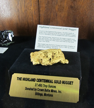
There is probably no more appropriate place for a mineral museum than in Butte, Montana, better known as the Richest Hill on Earth. The state itself is nicknamed The Treasure State, so with monikers like those, you know you’re going to see a lot of prized specimens! Situated on the Montana Tech Campus, the Mi One of the highlights in the Mineral Museum is the “Highland Centennial Gold Nugget” weighing 27.5 troy ounces. The nugget got its name because it was found in the Highland Mountains south of Butte in 1989. The nugget is believed to be the 7th largest gold nugget found in Montana. A 400-pound smoky quartz crystal, referred to as “Big Daddy,” was unearthed just east of Butte. Because of Montana’s long tradition of mining, you’ll see impressive examples of colorful bornite, garnet, azurite, agate, sapphires, and more. If you want to take a sample home, you’ll find small pieces for sale in the gift shop. There’s also a good selection of books relating to minerals. Don’t miss the museum’s display of fluorescent minerals. Cases are in a separate room and are illuminated in both long and short wavelength ultraviolet light. It’s amazing how ordinary-looking minerals radiate extraordinary vibrant shades of pink, orange, and blue when exposed to ultraviolet light. You won’t believe how halite (also known as salt) changes from white to red. Kids especially think it’s just plain fun being in the Fluorescent Room surrounded by a crazy glowing rainbow of rocks! The Montana Bureau of Mines and Geology Earthquake Studies office is also located in the Mineral Museum. Watch the seismic activity from Montana and around the world as it is recorded and printed on the seismographs. IF YOU GO Montana Tech Campus 1300 West Park St. • Butte, MT 59701 • (406) 496-4414
|
|
Nugget of News Blog |


 urn out to be quite so secret any more.